Enso Energy – Bramford Solar
A 242 acre industrial site of glass and metal instead of rural arable countryside
Current Status: Pending Appeal.
Due to this being a cross-boundary application, it had to be decided by both Babergh District Council and Mid Suffolk District Council.
Babergh voted to approve the application.
Mid Suffolk voted to refuse the application.
Overall the application is REFUSED.
HOWEVER, Enso have appealed to the Planning Inspectorate, and we are awaiting details of when that process will officially open for public participation.
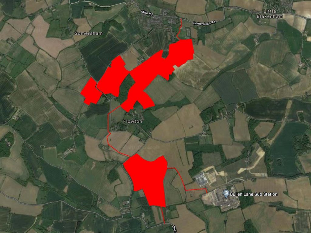
Enso Energy, through its subsidiary Bramford Green Ltd (sounds lovely doesn’t it) are proposing to develop a 98 hectare solar “farm” and battery storage facility on high quality arable land in Somersham, Flowton, and Burstall for 40 years that will export 49.9MW of electricity per year.
They “claim” that it will:
Supply 13,000 family homes per year
49.9MW is the equivalent of 437,124,000kWh per year. But the sun doesn’t shine all the time, so solar plants only generate electricity roughly 10% of the entire year, so that’s 43,712,400kWh. If the average household uses 3550kWh per year, that’s really only 12,740 homes. And if the government want us to all switch over to electric cars (the 40 year life of the solar plant would see the ban of new petrol & diesel sales come into force) then it’ll be closer to only 7,000 homes that it will be supplying electricity to.
Displace 21,500 tonnes of CO2 per year
The solar plant will connect into Bramford Substation, which is already a low carbon substation by serving nuclear and offshore wind plants, and which over their full life emit less CO2 per kWh than solar anyway. It is not replacing any coal or gas plants. So it’s unclear what CO2 emissions they’ll actually be displacing. Solar also takes up significantly more land space, removing arable land from UK production and increasing the need for more food imports (and the CO2 to transport it here).
Reduce 7,000 cars on the road per year
That’s a very strong, and misleading claim. Picture it. You’re stuck in traffic and all of a sudden 7,000 cars disappear, all because of the solar plant. But that’s not realistic. Because cars are only on the road 4% of the year. The rest of the time they are parked with the engine off. So at any one time that’s really only 280 cars. And it’s still only the CO2 emissions. It does nothing for the congestion, noise, and other exhaust emissions. So those cars you imagined gone, are really still there.
We’re not saying no to solar… we’re saying no to solar on high quality food producing arable farmland
Did you know that 98 hectares of arable land is…
242 acres or 979,339 square metres?
Or 128 Ipswich Town football pitches?
Or 3753 Wimbledon Doubles Tennis Courts?
Or 882,000 one kilo bags of wholemeal flour per year?
Or maybe 8,087, 560 pints of beer per year?
That’s an alarming amount considering the UK is only 64% self-sufficient for food,
but produced 38% more electricity than at peak demand in 2019.
It is 10 times larger than the new Eastern Gateway Industrial Park,
and larger than any industrial park in Suffolk.
Climate Emergency & Suffolk
In 2019 Babergh & Mid Suffolk made a joint Climate Emergency declaration, with the rest of Suffolk. And made a commitment for Suffolk to be carbon neutral by 2030.
Enso Energy claim that their development “will assist Babergh and Mid Suffolk District Councils to urgently reduce greenhouse gas emissions” and “contribute towards the security of energy supply in Babergh and Mid Suffolk District Councils through the provision of significant amounts of local, competitive renewable energy” by providing electricity for 13,000 homes.
However, what Enso Energy aren’t advertising in their brochure is that the development will connect into the transmission lines of the National Grid, where it will be exported to the rest of the UK. It WILL NOT be supplying Suffolk with any electricity at all, and it WILL NOT reduce any emissions in Babergh & Mid Suffolk.
In context, two offshore windfarms currently in operation off the Suffolk coast are the Galloper Wind Farm which produces 353MW for 380,000 homes, and the Greater Gabbard Offshore Wind Farm which produces 500MW for 530,000 homes. The East Anglia ONE Offshore Wind Farm currently in construction will produce 714MW for 630,000 homes. East Anglia THREE Offshore Wind Farm has been approved and will produce 1400MW for over 1million homes. East Anglia TWO Offshore Wind Farm currently under planning consultation will produce 900MW for 900,000 homes. East Anglia ONE NORTH Offshore Wind Farm also in planning consultation will produce 800MW for 659,000 homes. Sizewell B produces electricity for 2.2million homes. Sizewell C if approved would provide electricity for over 6million homes. These are all renewable and low carbon energy sources, to potentially supply 12.3million homes.
Suffolk has just over 346,000 household properties.
At present, the National Grid has no capacity to use the electricity generated by the Enso Energy scheme. There is no need at this location for more power generation as the off shore wind developments, which provide substantially better reliability and generation, will take up this capacity. Adding large-scale solar PV at this location limits the benefits of the off shore wind.
Agricultural Land
The proposed site area would cover 242 acres of high quality arable farm land. 82.1% of the area is classified at “best most versatile agricultural land”, also known as prime agricultural land. There is then 13.1% of not quite as high quality, but still arable land capable of producing food, and 4.5% of non-agricultural land. A further 10 acres will be disrupted during construction while cables are laid.
The current traditional crop rotation and good farming practices used on the proposed land were actually introduced back in the 1700s because they improved the soil, and therefore the crop yield. Even the developers own soil survey shows that it is high quality soil. The “intensive agriculture” they mention is not the same as the traditional methods used on this land, which has helped the soil maintain its high quality over the years.
The developer claims that the soils need to rest. So that it can rest from growing plants they propose to… grow another plant. Even more curiously they plan to replace the usual wheat and barley, both a type of grass, with… another type of grass. But grass is not a “resting” plant, because it doesn’t grow and then stop. It continues to grow, therefore needing cutting. Soil likes to grow plants. It is what it does and it isn’t familiar with the human concept of rest.
To convert such a large area of prime arable land over to such a small amount of solar power production would be a wasteful use of the land for a minimum of 40 years. Especially as climate change is reducing crop yields globally. To improve our environment and climate there is a need to reduce the carbon miles our food travels and improve our food security as the global population continues to increase.
Flooding & Water Management
Local residents, including those in Bramford, Somersham and Burstall, can attest to the fact that areas around the proposed development site are already prone to flooding. Even over the 2020/21 winter so far locals have seen road closures on several occasions around the proposed site, and the Gipping yet again breaking its banks.
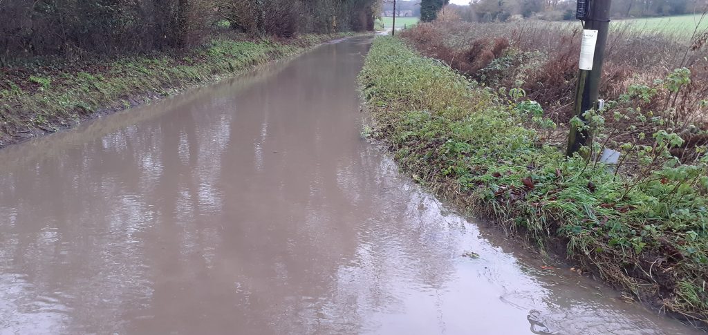
Already there are households excluded from flood insurance due to historic flooding of homes in the area. The UK Government is also currently advising that developments in this area should assume an increase of 35% in river flow over the time period covered by this proposed development. Despite this, as well as more water there is also going to be more homes at risk – with hundreds of planned new homes proposed for construction adjacent to the river Gipping. Worryingly, Enso Energy’s own Flood Risk Assessment references research indicating that solar installations on farmland have the potential to double the flow rate of surface water run-off, but even more worryingly is that the Flood Risk Assessment submitted indicates that surface water runoff from the battery storage area alone would almost triple! And their plan is to then feed that increased rate directly into an already known flood risk area – Burstall Brook!
Further more, the fields would be covered with around 125,000 solar panels containing known carcinogenic heavy metals. The only thing stopping these from entering the soil and water system is a sheet of glass. We are currently unaware of how 242 acres of land can be safely contained from preventing pollution into the soil and water systems. The Enso Energy (and EDF Renewables and Statkraft) site would be on land that contributes to the drinking water supply of Ipswich and surrounding villages. Suffolk County Council Flood and Water Management team have also expressed their concerns over these matters.
Battery Energy Storage System (BESS)
Enso Energy aren’t just proposing solar panels. They are also proposing a BESS of 20 large shipping containers. This is essentially a shipping container filled with stacks of (usually) lithium-ion batteries, up to 400 tonnes. They wish to use this to buy cheap electricity from the grid when demand is low, such as overnight, and resell it back to the grid at a higher price when demand is higher, such as when everyone wakes up to make their cup of tea or coffee in the morning.
Lithium-ion a notoriously unstable battery and an installation on this scale carries real dangers of explosion. These systems require close management and not abandonment in the middle of the Suffolk countryside where a small failure can lead to the risk of fire and explosion, which is unable to be extinguished, only controlled. To simply control a fire Suffolk Fire & Rescue would require enormous amounts of water (up to 500 gallons a minute to such a fire) whereas large fire tenders only hold 2000 gallons, enough for less than 5 minutes. There is no water main on site, and none planned.
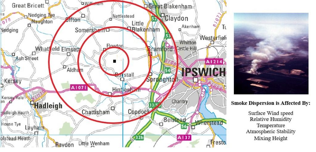
In such an incident a dangerous gas mixture with highly explosive, hazardous, and carcinogenic components is released (such as hydrogen fluoride), which could result in very serious and chronic injuries to people and animals. An Energy Development Consultant, Trident Energy Limited, has modelled the potential dispersion area of these toxic gases which is illustrated below. There are several different factors that would impact the actual dispersion area in the case of an incident, but the red circles represent the area based on 10mph, 20mph, and 30mph winds.
Landscape
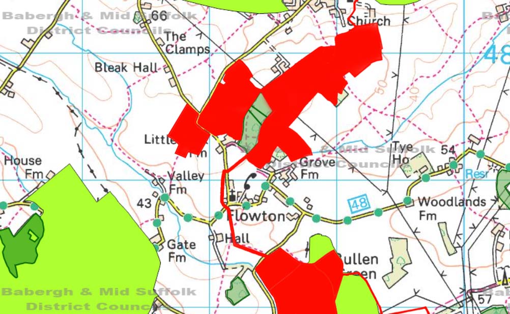
Flowton, Burstall, and Somersham are all nestled within an undulating rural area officially designated as a Special Landscape Area (SLA) which is protected in the Mid Suffolk Local Plan 1998. The map below shows the SLA in green, with the site outline in red.
To get to the site along Lower Road, Somersham and Church Hill, Burstall an average of 73 vehicles per day will need to travel through the SLA. Some fields are even in the SLA. The residential area of Flowton is a recognised extension of the SLA which will be surrounded by the site, and almost the entire site area overlooks the SLA.
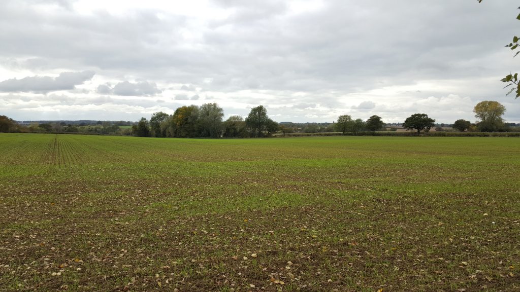
Let’s take field 1 for example. Field 1 is not within the SLA. But because of the undulating landscape, if you stand on the road wedged between field 1 & 2, the landscape melts away in front of you (along with any stresses you may have in that moment) to a great distance overlooking the SLA. The below photo shows that view.
If a photo can say 1000 words, standing in that spot will make you speechless!
UK Government guidance states “The deployment of large-scale solar farms can have a negative impact on the rural environment, particularly in undulating landscapes. However, the visual impact of a well-planned and well-screened solar farm can be properly addressed within the landscape if planned sensitively.” This is an undulating landscape. There is very little proposed screening, and with panels 3m high and fencing 2.2m high many of the views would be lost regardless. The site has not been planned sensitively to the views of the area and there is no regard for the setting it is in. The solar plant would dominate the landscape and cause a significantly detrimental impact to the Special Landscape Area.
Biodiversity
The fields where the solar fields are proposed are home to a huge variety of biodiversity, including many rare and endangered species, and the developer dismisses the importance of open arable land to their survival.
In particular, Skylarks and Yellowhammers are on the Birds of Conservation Concern Red List. Skylarks breed in many of the fields affected, as do Yellowhammers in the hedges surrounding them. Both would undoubtedly be seriously affected by the construction phase lasting 40 or more weeks, and almost certainly by the subsequent major change to their habitat.
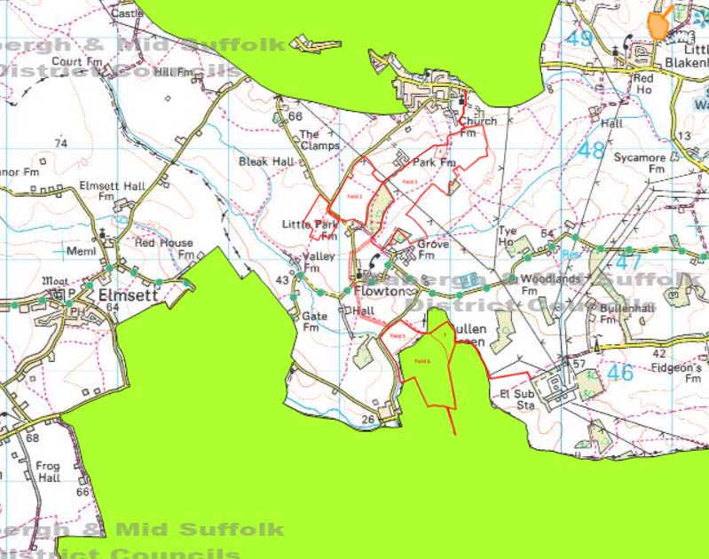
The area has a few listed ancient woodlands, but of most concern is the fencing in of the Somersham Park ancient woodland. See the green area surrounded by red in the below image? That is Somersham Park. Where the animals can freely come and go from the woodland now. If the solar plant is built they will be penned in on the 3 largest sizes, with the only open side opening on to an open bridleway and blind double bend in the road.
The developer has listed a grand total of 8 wildlife species in their biodiversity report. For a little context, within Flowton there is a lepidopterist (technical name for a moth specialist), who has recorded 15 vulnerable and potentially threatened species of moth (let alone the common ones) just in his back garden. But, as no systematic surveys of moths, butterflies or other invertebrates has ever been carried out, we simply don’t know what else may be present. If one garden has all this, a site of 242 acres must have more than just 8 species in it.
There are several ponds in the site, providing a valuable water source to grazing and roaming animals that would become inaccessible to them. There is a most significant Great Crested Newt habitat in Burstall immediately adjacent to the site boundary, that was formally studied by the National Grid a few years ago. They caught 600-700 GCNs in this one pond!
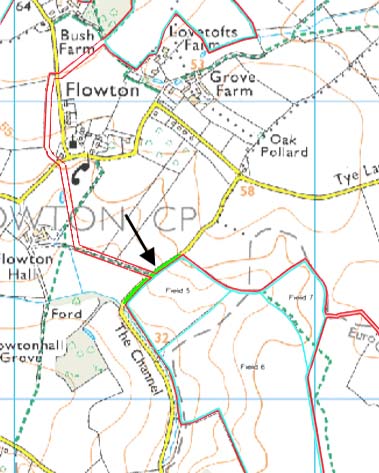
The site plan also proposes to bulldoze right through the middle of a designated (and protected) Roadside Nature Reserve (RNR), named Flowton 92. This RNR runs along the banks of The Channel, and is designated so for its Sulphur Clover (near threatened) and Man Orchid (critically endangered). The RNR is shown in green in the below map, and the site outline in red. Technology (called direct drilling) would allow the developer to install the cables under the RNR without having to destroy the top, but they refuse to use that!
The developer also proposes to cut down several healthy mature poplar trees as part of the development. These trees were planted in the 1970s to act as a wind break across the landscape, and as an early flowering tree they provide an early food source for insects, bees, and birds. They do not propose to replace them. We’re not sure where cutting down healthy trees comes into being “green”.
Traffic & Access
During the construction phase the traffic will be split between two routes. The northern parcel of land will be entered via Lower Road, through Little Blakenham, and into Somersham via the Village Hall entrance. The southern parcel of land will be entered via Burstall. The developer estimates an average of 5 HGVs per day, however there will be significantly more during the first month or two as they build the main site compound and internal access tracks with hardcore. With construction taking an estimated 10 months (40 weeks).
In Little Blakenham there is a very narrow part of the public highway called Leatherbottle Hill. It is barely wide enough for two cars to pass next to each other, let alone anything larger such as an HGV that may meet a van, school bus, another HGV, or an agricultural vehicle. Pedestrians and cyclists regularly travel through here, but there is no footpath. In fact, there is no footpath the entire length of Lower Road until after you get to Somersham Village Hall.
The entrance to Somersham Village Hall is shared access. The HGVs will enter the site and travel up the steep mud farm track on the left hand side. Whereas usual Village Hall parking is to the gravel area on the right. But they still share the same entrance. Which is also brick paved. This isn’t suitable ground surface for a barrage of heavy vehicles and may quickly cause bricks to dislodge and be a trip hazard to residents walking across it.
Talking about the Village Hall, this is also a designated car park for parents dropping off and picking up children from the nearby Primary School. We’re somewhat alarmed by the potential safety hazards of combining lorries and school children in such close proximity.
In addition to this, and our biggest traffic concern, is the number of workers. 60-70 construction workers will be needed on site. These workers are not required to travel down the B1113 and Lower Road. They can come from, and leave in, any direction they choose, including for breaks. The narrow roads around these villages are not suitable for such a large number of vehicles all needing to be in one place at the same time. Furthermore the developer has stated they will take no responsibility for the workers adhering to any time restraints (guidelines to avoid peak traffic for example) that they agree to as part of the development conditions, stating it will be up to the local authorities to monitor and enforce. The developer has suggested the workers will get to and from site using 3 mini bus trips, but we’re not sure how 60-70 workers will fit in 3 minibuses.
How can I help protect all of this?
Enso Energy have submitted their planning application to Babergh and Mid Suffolk District Councils and it is currently open for public comment.
There are two application references because it crosses district boundaries.
Mid Suffolk is DC/20/05895
Babergh is DC/21/00061
To submit your objection you click on the above links and head to the Comments tab, and then Make a Comment. Please note you will need to login or create an account to do so.
Alternatively you can send your objection to planning@baberghmidsuffolk.gov.uk. You will need to include the reference numbers above in the subject line, along with your full name and address in your email.
The DEADLINE for public comments is currently 27th March 2022.